terrio





Pure-Rust geospatial raster, vector and point cloud data I/O.
terrio reads, writes, converts and reprojects the geospatial formats most workflows use, without C dependencies. It builds anywhere Rust does, WebAssembly included, and it is tested file by file against GDAL on real-world data.
terrio info s3://sentinel-cogs/sentinel-s2-l2a-cogs/10/S/EG/2026/10/S2C_10SEG_20261010_0_L2A/B04.tif
terrio convert countries.shp countries.gpkg --where "CONTINENT = 'Europe'"
terrio warp dem.tif dem_utm.tif --t-srs EPSG:32613 -r bilinear
terrio rasterize counties.gpkg counties.tif -a FIPS --tr 0.01 0.01
Features
- Rasters: GeoTIFF, Cloud Optimized GeoTIFF, JPEG 2000, Zarr v2/v3, netCDF (classic and netCDF-4, with groups), HDF5, ERDAS Imagine, ENVI, Esri grids, GeoPackage tiles, VRT and more. See Formats.
- Vectors: GeoPackage, GeoParquet, FlatGeobuf, Shapefile, GeoJSON (and GeoJSONSeq), CSV, XLSX, KML/KMZ, GML, GPX, TopoJSON, MapInfo and OpenStreetMap PBF, with layers larger than memory read and converted as streams of features in the formats that allow it; and ArcGIS feature-service JSON and protocol buffers, whose layers are read into memory whole.
- HEC-RAS: the 2D meshes, cross sections, structures and other features of HEC-RAS geometry and plan HDF files, with their stored attributes and results, as vector layers. See HEC-RAS.
- Point clouds: LAS 1.0 to 1.4 (with waveforms), LAZ, COPC, PLY and E57, read and written,
and EPT read; remote COPC and EPT read by bounds and octree level; files larger than memory in
chunks; PDAL's filters (SMRF ground classification, outliers, ranges, sampling, voxels);
gridding to DEMs as PDAL and
gdal_griddo. See Point Clouds. - Cloud data in place: HTTP(S) range requests,
s3://,gs://andaz://objects, zip archives, and GDAL's/vsicurl/,/vsis3/,/vsizip/prefixes. Remote COGs are read window by window. See Remote Data. - GDAL-style operations:
translate,warp(14 resampling methods),mosaicand VRTs,rasterize,polygonize,dem,calc,contour, overviews, andconvertwith OGR SQL filters. See Command Line. - Coordinate reference systems: EPSG codes, WKT, PROJ strings and
.prjfiles, identified and transformed the way GDAL does. See Coordinate Systems. - Every interface: the command line, a Rust library, a Python package with NumPy arrays, an npm package compiled to WebAssembly, an MCP server for AI agents, and a browser UI for the commands. Try it in the playground or the notebooks, with nothing to install.
Browser UI
terrio ui serves every command as a form in your browser, from your own computer:
terrio ui
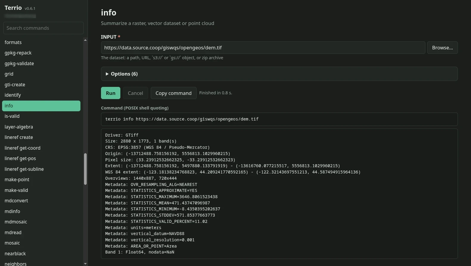
Pick files with the built-in file browser or enter a URL, run or cancel the command, read its
output, and copy the equivalent command line into a script. See ui for the options,
the security model and the limits.
How terrio relates to GDAL
terrio is not a port of GDAL. It covers the formats and operations that most geospatial workflows
need, with GDAL's behaviour as the reference: every driver and operation is compared with GDAL on
real files, and differences are treated as bugs. See Testing Against GDAL and
Coming from GDAL. For how terrio compares with the gdal crate, the GeoRust crates
and other Rust options, see Why terrio?.
The format codecs and projections build on the pure-Rust crates of
whitebox_next_gen (wbraster, wbvector,
wbprojection); terrio adds its own drivers where those are wrong or missing.
Status
terrio is in early development. The API may change before 1.0. See the roadmap.
License
MIT, except the point cloud eigensolver (MPL-2.0). See NOTICE.